|
|
 For close to 100 years it was devoid of life. A river of seemingly marvelous opportunity, but, in reality, as empty of life as any corpse. And corpse it was - neither fish nor animal nor plant alive in its cold crystalline waters. A river of beautiful glides, imposing rapids, and deep mysterious pools full of promise, but as empty of substance as a prostitute's kiss. For close to 100 years it was devoid of life. A river of seemingly marvelous opportunity, but, in reality, as empty of life as any corpse. And corpse it was - neither fish nor animal nor plant alive in its cold crystalline waters. A river of beautiful glides, imposing rapids, and deep mysterious pools full of promise, but as empty of substance as a prostitute's kiss.
The culprit was acid runoff from mining operations. The same culprit that has ruined countless waterways across the country. In this case, coal mining was the villain. In different locales, the search for copper, gold, lead and other minerals has destroyed nearby streams.
In Western Maryland, on the North Branch of the Potomac, however, the situation has improved dramatically. As a result of cooperation between an environmentally conscious mining concern, and an enlightened state Cold Water Fisheries Department, the North Branch is now delivering on what was once only an empty promise.
Mining began in Western Maryland's coal rich mountains somewhere around the turn of the century. At the time, "environmental impact" was an unknown phrase. Coal mining was done indiscriminately, with little knowledge of, or concern about, the adverse effects it would have on the local environment. As the surface coal was removed, operations went deeper and, inevitably struck water. Water, which is neither a by-product of coal mining, nor desirable; it simply is encountered as the mine shaft goes deeper. Iron Pyrites (often called Fool's Gold) is a sulfur laden mineral, present in large quantities amidst the coal deposits. Normally the Pyrites are encapsulated in the coal and are thus harmless, but when exposed to air or water, as happens during the mining process, combine with the water to produce sulfuric acid. Since the water could not be contained, and the old mining firms gave no thought to the havoc they were creating, the runoff simply went into the nearest watercourse, in the process, killing all aquatic life for many miles. Today, this situation is accounted for and corrected in the mining process, and remedial action is being applied to undo the damage caused by the old operations now abandoned.
The Mettiki Coal Company now owns most if not all of the coal mines in Western Maryland, and a good portion of those in neighboring West Virginia. This company typifies an environmentally responsible corporation. All of the water encountered in their mining operation, along with that emanating from the abandoned shafts which Mettiki controls, is funneled to a huge collecting basin 600 feet underground. From there 450 HP pumps bring it to the surface where it is treated with calcium carbonate (limestone) to neutralize the acid, settled, aerated, and only then released into a tributary of the North Branch. This operation effectively introduces the equivalent of 4 tons of lime per day into the Potomac helping to neutralize the acid coming from other locations upstream. This program is the first in this country to address the problem of mine runoff.
So good did this water quality appear to be, that the state, in conjunction with the Mettiki corporation, began an experimental trout rearing program. Pens were constructed that are fed entirely by the treated outflow, and, in September of 1993, 400 browns and rainbows were delivered to Mettiki as a test batch to determine if conditions were as ideal as perceived. The results have been outstanding. Approximately 10 million gallons per day of treated water flow through the pens and into the South Fork of Sand Run, a major tributary of the Potomac. With a pH of 8.1, a dissolved oxygen content of 8 parts per million, and a constant temperature of between 52 and 60 degrees year round, conditions are ideal for raising trout and allow for growth through the normally dormant winter months. The growth rate is phenomenal, a one year old rainbow weighs 1 2 pounds - almost twice the norm, and the facility has the potential to produce 100,000 trout annually.
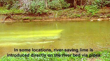
The problem facing the river now is not from Mettik's current mining operations, but rather from those that were previously closed. Although many mines in the area are no longer active (coal having dropped in price to $24 per ton as opposed to $75 per ton in the mid seventies) water still courses through the abandoned mines carrying with it its deadly cargo of sulfuric acid. To combat this, and the effects of acid rain, the state has installed four limestone dosers on tributaries of the North Branch.
 These devices, developed in Sweden to combat acidity in some Swedish Salmon rivers, look like small silos, and automatically dump pre-determined amounts of limestone into the river. Combined, they use about 2 2 tons of limestone per day. Water which previously had a pH of less than 4 (almost like vinegar) now runs at nearly 8, slightly alkaline, and very conducive to aquatic life. These devices, developed in Sweden to combat acidity in some Swedish Salmon rivers, look like small silos, and automatically dump pre-determined amounts of limestone into the river. Combined, they use about 2 2 tons of limestone per day. Water which previously had a pH of less than 4 (almost like vinegar) now runs at nearly 8, slightly alkaline, and very conducive to aquatic life.
Although most of the improvements to water quality occurred fairly recently, conditions actually began to get better in 1977 with the enactment of the Surface Mining Act. This law required all mining operations to clean up their operations and imposed stiff penalties for failure to comply. Around the same time, 18 miles downstream from the Maryland West Virginia border, the Army Corps of engineers began building the Jennings Randolph Dam. Although we fishermen tend to regard any dam as potentially destructive and undesirable, this one has actually helped restore a lost fishery. Originally conceived as a flood control project, the dam was also to serve as a means of controlling acid levels downstream. Included in the design of the dam (completed in 1982) was a large concrete tower with 5 water intakes at different depths.
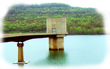
Since this is a deep lake (at 270 feet - the deepest in Maryland) there was no doubt that it would stratify in multiple layers based on temperature and pH levels. The original intent was to mix water from different depths in an attempt to regulate the acid levels and the water temperature in the outflow. Since the water entering the lake was expected to be so acidic, the internal valves and piping of the tower were made of stainless steel to combat corrosion. This proved to be unnecessary because of results already achieved by the limestone dosers. The expected pH levels of 3 to 4 never occurred; in fact, once the lake began to fill, the pH level never went below 6 - an unexpected and very desirable happening. Presently, the lake has a stable pH level of better than 7 and smallmouth bass (which are much more sensitive to acid water than trout) are now living in the lake. The ability to draw water from different depths is now used to control temperature and oxygen levels of the outflow.
Maryland's Department of Natural Resources, recognizing the excellent water quality now available, constructed trout rearing pens just below the dam. Trout thrived and grew rapidly. The problem now was that the river had little or no food for the organisms on which trout feed, and despite water quality, it would take years before the aquatic life returned. The trout could be raised and fed in the pens, but forage in the stream would be scarce.
As it turned out, the waste products from the penned trout, the disposal of which is normally a hatchery problem, became a benefit, introducing needed fertilizer to the downstream water. At present, insect life is still sparse, but improves every year. The grasses are returning and forage fish are becoming plentiful. Expectations are that within 5 years, the river should be in excellent shape. In fact, Bob Lunsford, Director of Maryland's Fresh Water Fisheries, feels that the river may end up in better condition than would be normal for a stream in that area - the coal deposits being responsible for a normally acidic geology.
What all this means, is that 21 miles of prime trout water (13 above the dam and 8 below) now exist where previously there was none. Although stocking of respectable size fish is responsible for the bulk of the trout you are likely to catch, put and grow is the procedure in the catch and release area below the dam where only fingerlings are stocked and allowed to mature. There is also some natural reproduction being observed both above and below the dam, and as the insects and bottom life continues to proliferate, should get better and better. Certainly the water is cold enough with an average 55 - 60 degree water being released from the dam.
The river above the dam is regulated as delayed harvest. No fish may be taken from January 1st until June 15th; thereafter 2 trout per day are allowed until December 31. Below the dam, there is a catch and keep section, subject to normal regulations, that is stocked with mature fish, as well as a 4 mile catch and release section. As mentioned, only fingerlings are stocked in this portion of the stream, but inevitably larger trout move into this area from the stocked portions. The first 3/4 of a mile downstream from the rearing pens at the base of the dam is off limits. There is talk of opening this up to fly fishing only, catch and release. If this occurs, it will be one of the best areas anywhere.
Food supplies are still limited, and it is expected that stocking will have to continue for some time. but as insects and forage fish colonize the river, it is hoped that it will become a self sustaining river of wild trout. Meanwhile, there are some truly big trout present. Recently, a new state record was set with a monster brown trout of over 12 pounds.
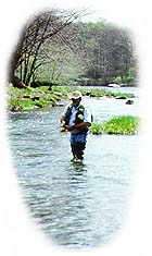
Divided as it is by the Jennings Randolph Lake, the river differs somewhat in character. Above the lake can best be described as "wild and wooly." It's big, fast and deep with steep, densely wooded hillsides. In the spring, wild flowers and bird life abound. On the Maryland side of the river, movement upstream or down is hampered by a lack of trails and thick stands of mountain laurel. Best access is gained by crossing to the West Virginia side, where a railroad track parallels the river. You can walk upstream for 8 miles before encountering another road. Those willing to walk can have large stretches of the river completely to themselves. Below the dam, the gradient is less, and the river is not quite as swift, sporting fast riffles rather than rapids. The North Branch is a big river, especially by eastern standards. It's 100 feet wide in places, and carpeted with smooth slippery rocks (a by-product of the lime treatment is a slippery calcium deposit on the bottom). It's not as bad as some New England streams, but felt soled waders are a minimum requirement, and stream cleats are better. A wading staff is a must.
My first impression of this stream was one of awe, accustomed as I am to the streams near where I live. Were you to be blindfolded and transported here and then asked where you were, it is unlikely that you would think of western Maryland. The North Branch of the Potomac is much larger and wilder than the typical eastern trout stream, and the surroundings are incredibly beautiful. Hard to believe that a stream of this magnitude exists so close to major urban centers.
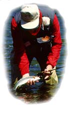
The fishing is nothing short of outstanding. On a recent trip there with several Department of Natural Resources personnel, I watched while a state biologist hooked and released two of the biggest rainbows that I have ever seen taken. We estimated that each fish was over three pounds, and each took better than ten minutes to land. Certainly excellent results anywhere, and outstanding for this area.
Besides the fishing, one of the purposes for this trip was to monitor and evaluate insect activities. A number of different mayfly nymphs were collected, a lot of stonefly shucks were seen and a few Caddis flies were hatching. Obviously, insect life is re-establishing itself. There are also lots of bait fish now; in fact, fishing this river is most productive with a streamer pattern or a large impressionistic fly like a wooly bugger. When we fished there, a black nose dace and little rainbow trout (Keith Fulsher's Thunder Creek series) did well on rainbows. The two large trout, taken by the biologist, went for a dark olive wooly bugger. I'm inclined to think that fly pattern is not too important right now. Mimic something edible and present it properly and you should catch fish.
Unlike the residents of many of the trout streams that we fish, the trout caught here can be quite large (remember the state record of 12 pounds). On an average day, it is quite reasonable to expect to catch a trout over 2 pounds. Not only are the trout large, they are spectacular fighters because of the cold swift water in which they live.
We were there in mid May - very early spring at this elevation. At home, 150 miles closer to the Chesapeake Bay and 3500 feet lower, dogwoods had finished blooming and all trees were in full leaf. On the North Branch, spring was just beginning, so there was not a lot of insect activity to observe. My feeling is, that given the current lack of a specific hatch, attractor patterns and flies that suggest a number of insects would produce best. For the calmer waters, an Adams or Elk Hair caddis would be a good choice, but for most of the stream, high floating patterns such as the Wulff series or the Humpy, in different shades, would be best. Later in the year, ants would be a good bet as there are many overhanging trees. As previously mentioned, streamer patterns are always a good choice.
The North Branch flows through a region that is sparsely populated, and surprisingly wild considering that it is but a 3 hour drive from Baltimore or Philadelphia. This region is a mountainous (by eastern standards) heavily forested area. Despite the fact that It is not far from a popular Maryland vacation area - Deep Creek Lake - fishing pressure is light. We saw only a few other fishermen during the course of several days, and these were near the roads. People visiting Deep Creek seem, for the most part, to be interested in the fishing, swimming, and "omigod" water skiing opportunities that the lake affords, and show little or no interest in the trout fishery nearby.
People who do come to the area for the trout fishing usually head for the more highly publicized Savage river not far away. The locals are aware of this fishery, but most out-of-towners remain "in the dark" about this river; the North Branch of the Potomac has yet to be discovered.
The North Branch is in the extreme northwest corner of Maryland where it forms the border between Maryland and West Virginia. To reach the lower river, leave Interstate 68 at exit 34 near the town of LaValle. Turn left on Rt.. 36 south towards Westernport. At Westernport, turn right on Rt.. 135 west. Go approximately 2 miles to the Westvaco Paper Plant. Turn left and cross the river into West Virginia. Pick up Rt. 46 west (this will be a gravel road). Go 3.6 miles to the first right (unmarked, but still Rt. 46. Go 1/4 mile to the next right (still Rt. 46). Go 1 mile to the second of two white churches (Calvary Pentecostal) and again turn right. After about two miles you will reach the little West Virginia village of Barnum. Don't blink - it's easy to miss. At the bottom of the hill there is an interesting fishing store called Pop's. Stop in, you will be amazed at the pictures of large trout on the wall. Just down the hill from the store is a dirt road that parallels the river. A couple of miles downstream, vehicular traffic is stopped by a metal gate across the road. This is the beginning of the 4 mile catch and return area and is only accessible by foot, or possibly mountain bike. There's an interesting thought; if you happen to own a mountain bike and you want to fish this river, bring it with you. You could cover a lot of river in this manner, and, should it be crowded, you could really get away since there is no other access for miles.
The river above the lake can be reached via Wallman Road, Laurel Run Road and Lost Land Run Road. All are dirt/gravel roads within the Potomac State Forest. From the town of Oakland, you can reach Lost Land Run (the area we fished) by taking route 560 south towards Gormania. Go left at Bethlehem Road to enter the State Forest and follow the signs to the river.
There is one caveat! For four weekends each spring two in April and two in May, additional water is released from the dam to accommodate white water enthusiasts. Fishing the river below the dam can be difficult and the wading dangerous. Although I can understand the desire of participants in these activities to have the greatly increased water flow, it's possible that this unnatural amount of water could scour the stream bottom, severely damaging an ecological system struggling for a foothold. If you are considering a trip to the North Branch at this time of year, and you want to fish the tailwaters, call (301) 962-7687 for a water release schedule.
Accommodations are available nearby. There is a good Econo-Lodge in Keyser West Virginia, and the Town Motel in Oakland is very nice and quite reasonable. The town of Casselman, about a half hour away, has a charming old inn with a good restaurant, and is close to another worthwhile trout stream. The Potomac State Forest also has primitive camping sites for those so inclined. Cost is negligible.
This river has enormous potential. Bob Bachman, overall Director of Maryland's Fisheries Department, was the person who originally believed that the North Branch could be salvaged. You may remember Bob as the man responsible for the restoration of the Gunpowder River just north of Baltimore. He feels that the North Branch could well rival the fabled Madison! If so, it will certainly demonstrate what can be accomplished with vision and good environmental practices. Not only that, it will provide a state (not known for its trout fishing) with one of the best rivers in the country - a possibility considered unthinkable only a few years ago.
|


 by Ed Russell